This site is best viewed in landscape mode on smartphones.
Support Local News? Support Oggy Bloggy Ogwr
Oggy Bloggy Ogwr doesn’t receive any subsidy and isn’t funded by the BBC. If you like what I’m doing here and think this work is important in keeping locals informed of what’s happening in Bridgend, consider a donation. One-off or monthly; as little or as much as you want. Click the links below, or full details are available here.
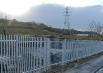
A planning application has been submitted for 22 social houses on land at Waterton Lane.
A planning application for housing on the land was granted conditional consent in 2016. However, only part of this development (Ffordd Melin Ddwr at the former Model T pub/Waterton Manor) was completed.
The land is classed as brownfield as it has previously been used for storage. Although it hasn’t been included for housing in the current Local Development Plan (which runs until 2033), it was included for housing in the previous one.
The proposal includes 10 two-bed houses, 8 three-bed houses and 4 one-bed apartments. An access road would be built alongside the riverbank linking to Ffordd Melin Ddwr.
Land “meets flood risk guidelines”
The plot of land is directly next to the River Ewenny. Bridgend Council withdrew a strategic development site to the west (Parc Afon Ewenni) from the Local Development Plan because of the flood risk.
A flood report submitted alongside the application confirms that the proposed development would be at “moderate risk” of river flooding.
Their modelling – taking climate change into account – projects that if the River Ewenny has a 1-in-100 chance flood, it would be mainly confined to the southern part of the site, which has been set aside for the access road.
In a 1-in-1000 chance flood, the expected water depth would be up to 60 cm, which is “considered tolerable within Highly Vulnerable (to flooding) developments”.
They recommended that future residents be made fully aware of the flood risk and sign up to Natural Resource Wales alerts, alongside a flood response plan.